Guilin's landscape is the best in the world. As a unique scenic spot resource, it has long been famous at home and abroad. Its three major features, typical karst landforms, beautiful Lijiang River scenery and rich landscape culture, have attracted worldwide attention. In 1982, it was designated as a national key scenic spot by the State Council. In order to fully, accurately and objectively understand the scenic spots and resources of Guilin Lijiang River, so as to scientifically, reasonably and feasiblely establish the Guilin Lijiang River Scenic Spot with legal zoning significance, this plan will determine the research scope as the Lijiang River Basin above Yangshuo County (including Yangshuo County) and part of the Xiangjiang River source basin (Haiyang Mountain) and part of the Liujiang River Basin, which is closely related to it. It basically covers the typical scenic spots and resources of Guilin Lijiang River and other related scenic spots and their endogenous environment.

The Li River was once called Guishui, or Guijiang, Guishui, and Dongjiang in history. It flows through Guilin, the third largest city in Guangxi Zhuang Autonomous Region and the political, economic, transportation, cultural and tourist center. It is a famous scenic spot at home and abroad for its unique and beautiful natural landscape, Guilin landscape, which is beautiful with beautiful mountains and clear waters, and beautiful caves and rocks. The Li River belongs to the upper reaches of the Gui River in the Pearl River system. It originates from the south side of the old mountain boundary of Yuechengling at an altitude of 1,732 meters at the junction of Xing'an and Ziyuan counties, and belongs to the mid-subtropical monsoon climate zone. The Li River Basin has rich natural landscapes. As early as the Southern Song Dynasty, "Guilin landscape is the best in the world" was already famous all over the world. The Li River, this beautiful river lingering in the southern border of the motherland, has attracted countless literati and poets since ancient times with its long history and civilization. "The mountains and rivers make tourists drunk, and the poems are printed in their hearts" is the emotion expressed by countless tourists.

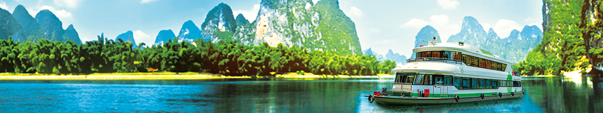
"The river is like a green silk belt, and the mountains are like jade hairpins." The landscape represented by the Lijiang River and the karst caves is known as the "four wonders" of green mountains, beautiful waters, strange caves, and beautiful stones. The 83-kilometer Lijiang River section from Guilin to Yangshuo, also known as the Lijiang Essence Tour, also has the beautiful scenery of "deep pools, dangerous shoals, flowing springs, and waterfalls". It is a typical, rich and concentrated area of karst terrain development, which concentrates the essence of Guilin's landscape and makes people feel that "the boat is swimming in the water and people are swimming in the painting." There are 179 cruise ships in the scenic area, all of which are ordinary air-conditioned ships and luxury air-conditioned passenger ships, including 97 cruise ships that have won the "Civilized Route" and "Youth Civilization" titles from Guilin City, the Autonomous Region, the Ministry of Transport, and the Central Committee of the Communist Youth League. The Mopanshan Passenger Terminal, which has invested more than 20 million yuan to build, is a "window" for Guilin City to the outside world. It is 28 kilometers away from the urban area of Guilin and is named after the proximity to Mopanshan. The wharf covers a total area of 233,350 square meters and has complete supporting facilities: it has five waiting rooms, including one for the disabled, three for ordinary passengers and one for VIP passengers. The wharf adopts a garden-like design, combining landscape with mountains and water.
In November 1982, the Li River was listed by the State Council as the first batch of national key scenic spots and required to be protected. In December 1991, the Li River Scenic Area ranked second in the list of "Top 40 Chinese Tourist Attractions" announced by the National Tourism Administration. In November 1996, the Li River was listed as one of the 13 rivers under national key protection. In April 1997, the Guilin-Yangshuo route was rated as "Guangxi Waterway Civilized Route" by the Guangxi Transportation Department. In May 1998, the Guilin-Yangshuo tourist route was awarded the "Guangxi Waterway Civilized Route" by the autonomous region. In July 1998, it was identified as the first batch of "National Civilized Scenic Spots and Tourist Areas Demonstration Points". In December 1998, the Autonomous Region Spiritual Civilization Construction Committee awarded the Guilin-Yangshuo route as the "Guangxi Civilized Route". In December 2000, the Ministry of Transportation awarded the Guilin-Yangshuo route as a ministerial "civilized route"; awarded the Mopanshan Wharf a ministerial "first-level civilized passenger station" and awarded the Zhujiang Wharf a ministerial "third-level civilized passenger station". The Lijiang River Scenic Spot was rated as a "National AAAAA-level Scenic Spot" by the National Tourism Administration. In January 2001, the Lijiang River route, known as the "Golden Waterway", was rated as a "Ministerial Civilized Route" by the Water Passenger Transport Tourism Management Committee of the China Transportation Enterprise Management Association. In April 2002, the Lijiang River Tourism Management, managed by the Guilin Transportation Bureau, passed the ISO9001 international quality management system, ISO14001 environmental protection management system, and OHSASI8001 occupational health and safety three international management system certifications.
Cruise along the Li River and you will fully appreciate the magnificent landscape, feast your eyes on the beauty of nature, and leave behind unforgettable memories.
02 Guilin's Geographical Location
Guilin is a world-famous scenic tourist city and historical and cultural city. It is located in the southwest of the Nanling Mountains and the northeast of the Guangxi Zhuang Autonomous Region, 109°45'-104°40', and 24°18'-25°41' north latitude. Guilin is located in the southwest of the Nanling Mountains, the northeast of the Guangxi Zhuang Autonomous Region, and the southern end of the Hunan-Guangxi Corridor. It is adjacent to Hunan in the northeast. The Hunan-Guangxi Railway and the Lijiang River run through it, and the Guiyang-Guangzhou High-speed Railway under construction crosses the entire territory. There are three national highways 321, 322, and 323 passing through it. It is located at 109°36′ to 111°29′ east longitude and 24°15′ to 26°23′ north latitude, with an average altitude of 150 meters. It borders Hunan in the north and northeast, Liuzhou City and Laibin City in the west and southwest, and Wuzhou City and Hezhou City in the south and southeast.
Guilin is a world-famous scenic tourist city and historical and cultural city. It is located in the southwest of the Nanling Mountains and the northeast of the Guangxi Zhuang Autonomous Region, 109°45'-104°40', 24°18'-25°41' north latitude. It governs 5 urban districts, namely Xiufeng, Xiangshan, Qixing, Diecai and Yanshan, and 12 counties, namely Lingchuan, Xing'an, Quanzhou, Lingui, Yangshuo, Pingle, Lipu, Longsheng, Yongfu, Gongcheng, Ziyuan and Guanyang, with a total administrative area of 27,809 square kilometers. The urban area covers 565 square kilometers. Guilin has a long history. According to the relics found in the Baojiyan and Zengpiyan caves in the urban area, it has been verified that the Zengpiyan people had entered the matriarchal society stage about 10,000 years ago.

Guilin's landscape is a tropical karst landform represented by peaks and depressions. There are many underground caves, mainly soluble arch caves. The peaks and forests can be divided into isolated peaks, sparse peaks and peak clusters. Strange peaks and caves are typical characteristics of tropical karst.
my country's modern karst developed on the basis of the quasi-plain after the Yanshan Movement. The Guilin area, which is the material basis for the development of karst landforms, has a wide distribution of carbonate rocks (such as limestone, dolomite, gypsum and rock salt). In the Tertiary Period, it had a tropical climate and peak forests began to develop. In the Neogene Period, a monsoon climate was formed, laying the foundation for the current karst zonality, and the humid and hot climate has made the karst development turn intense. Especially since the Quaternary Period, the earth's crust has risen rapidly, and karst landforms have developed rapidly with complex and diverse types.

Guilin is located at low latitudes and has a subtropical monsoon climate. The climate in the territory is mild, with abundant rainfall, long frost-free period, sufficient sunshine, abundant heat, long summer and short winter, distinct four seasons, and basically the same season for rain and heat. The climatic conditions are very favorable. The average annual temperature is 19.3℃. July is the hottest month with an average monthly temperature of 28℃, and January is the coldest month with an average monthly temperature of 7.9℃. The average annual frost-free period is 309 days, and the average annual rainfall is 1949.5 mm. The average evaporation is 1490-1905 mm. The average annual relative humidity is 73-79%. The wind direction throughout the year is mainly northerly, with an average wind speed of 2.2-2.7 m/s. The average annual sunshine hours are 1670 hours. The average air pressure is 994.9 hPa.
 桂公网安备 45030502000450号